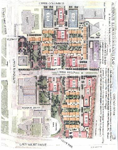
Magellan (Fujikawa 9/30/99) compared to Ward Alternate (11/2/99)
When the Fujikawa Plan was presented by Mr. Carlins of Magellan, the community voiced their concern about the short distances between buildings. Richard Ward simply rearranged the park and the buildings that were too close. The Fujikawa Plan was removed from consideration...Magellan promises a more acceptable plan in May or June. It will immediately be published by the New Eastside Forum and everyone on the mailing list will be notified by Email. You will also be given the Email addresses of the decision makers so that you can register your opinion of the new plan.
Text
360
360
400
400
155
155
175
175
195
195
Blue Cross
Blue Cross
School
To Navy Pier
To Millennium Park
Richard F. Ward
155 Harbor Drive, 5101
Chicago, Illinois 60601
Email: wardfam@idt.net
Home & Fax: 312, 938-0884
October 22, 1999
Mayor Richard M. Daley
City Hall
121 North LaSalle, Room 507
Chicago, Illinois 60602
Dear Mayor Daley,
The current issue of the Landscape Buyer magazine is enclosed and contains my public thank you for maintaining the vigil of preserving our beautiful lakefront for future generations. I would like to add my personal thank you for injecting an enthusiasm throughout the city that is contagious.
My attached memo to Joel Carlins suggests a diagonal park connection from the new Millennium Park to Navy Pier that would continue Daniel Burnham's vision of connecting major civic centers of public activity. Yesterday, Ed Uhlir was alerted that this opportunity for the shortest walking connection would not be available again.
The other idea the memo advances is the need for both the city and developer to be sympathetic to existing owners that become victims to old "Planned Developments" that gave blanket authority but contained no specific planned layouts or required timetables. Recent ordinance amendments should prevent new problems but the existing "unplanned developments" such as the 1969 Illinois Center PD #70 are still haunting our citizens. They were required to make buying decisions based on nonexistent information.
Respectfully,
Richard F. Ward
Richard F. Ward
155 Harbor Drive, 5101
Chicago, Illinois 60601
Email: wardfam@idt.net
Home & Fax: 312, 938-0884
November 5, 1999
Mayor Richard M. Daley
City Hall
121 North LaSalle, Room 507
Chicago, Illinois 60602
Dear Mayor Daley,
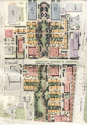
As a follow-up to my hand delivered letter of October 22, 1999, I have enclosed the Alternate Illinois Center Site Plan that is a re-arranged version of the Magellan plan that was previewed on October 8th. Last Tuesday at the New Eastside Association of Residents (NEAR) meeting, Joel Carlins withdrew this initial plan because of resident concerns with the location of the proposed buildings. He advised that he was meeting with a new planner on Thursday and would return in January.
The alternate plan that I presented was well received by both Alderman Natarus and your planning department representative, Benet Haller. The Alternate Plan links our new Millennium Park and Navy Pier and also protects the residents in the 5 existing buildings who made buying decisions without the benefit of knowing the layout of future buildings.
Respectfully,
Richard F. Ward
To: Joel Carlins
From: Richard Ward
Subject: Burnham's 1909 Plan of Chicago
Date: October 21, 1999
We have an opportunity to continue what Daniel Burnham, the father of modern city planning, envisioned on July 4, 1909 when the Plan of Chicago was published. He recommended that our centers of civic and cultural activity be linked by a series of parks and boulevards. If he were with us today, Mr. Burnham would see an opportunity to diagonally link the Millennium Park with Navy Pier. If we step back to view the east-west axis, it includes: the Civic Opera House, City Hall, State of Illinois Building, Randolph Theater District, Cultural Center, Millennium Park, and Navy Pier. Now envision the north-south axis from Jackson Park, to McCormick Place, Museum Campus, Grant Park with Buckingham Fountain, Art Museum, Chicago Symphony, Millennium Park, North Michigan Avenue Water Tower, and beyond to Lincoln Park. The 1909 east-west axis was planned to be Congress as revealed by the Michigan Avenue Gateway and Buckingham Fountain. However, the axis has evolved to Randolph.
The landfill that was partially completed 150 years ago by the Illinois Central Railroad and finally completed by Burnhan 100 years ago now is a "blank page" opportunity to complete this linkage of major civic sites. For the last year I have been studying the history of the Illinois Center property. I now watch the construction of the Millennium Park from our 51st floor vantagepoint, and also view the "blank page" Illinois Center opportunity. Recently on October 9th, I took the attached picture from the Blue Cross boardroom on a tour of the building with my wife Lydia and Charlotte Lauder, our tour organizer. A key piece of the diagonal park linkage between the new Millennium Park and Navy Pier appears at the bottom of the picture. This site is designated as a "multi-purpose field" in the 1993 and 1996 revisions of the Planned Development #70 ordinance. The Buckingham condominiums are on the left edge of the picture and Chicago Harbor is visible in the background.
Last night while listening to the Buckingham residents' concerns about losing their views to a "wall of nearby buildings", my year old vision of a diagonal linkage between the new Millennium Park and Navy Pier appears to resolve the concerns of all 5 of the existing residential buildings in the southeast corner of the Planned Development #70. By wrapping the required 6-acre park around the 5 buildings, their years of very real fears and uncertainty would be resolved. My experience with most "planned developments" details the size and layout of all of the buildings in the initial approval of the plan by the municipal authorities. But the 1969 PD#70 did not give any comfort to our citizens concerning their future views. So we must be extra sensitive to those who already live here and have made a significant financial decision based sometimes upon a real estate salesperson's advice or inaccurate projections. Future new residents and new commercial owners will have the benefit of knowing what the entire development will look like when it is completed and they can make their buying decisions with the comfort of that knowledge.
The Landscape Buyers magazine in the Fall, 1999 issue published my cover story series of articles on the Millennium Park and the new Busway and is offered as further reference. The new multi-modal transportation center being developed within the Millennium Park complex will link the subway and elevated trains via the Pedway with automobile parking, surface buses, the Busway, and the Southshore Metra. The required "continuous walkway system" in the PD#70 area will be a natural extension. Someday Chicago may have funds to complete the Pedway system to Navy Pier.
It would be appreciated if the Chicago Department of Planning and your development associates would study the suggested "diagonal park link" wrapping around the 5 existing residential buildings. Would this be the preferred option of Mr. Burnham and his partner Mr. Bennett if they could share their thoughts with us today? It could be a beautiful walk for our citizens and visitors to our great city.
Richard F. Ward
155 Harbor Drive, 5101
Chicago, Illinois 60601
Email: wardfam@idt.net
Home & Fax: 312, 938-0884
December 26, 1999
Joel M. Carlins, President
Magellan Development Group, LTD.
875 N. Dearborn Street
Chicago, Illinois 60610
Dear Mr. Carlins,
This is a follow-up to my letter of December 18, 1999 to Alderman Natarus regarding the apparent elimination of the PD#70 requirement for a continuous enclosed all-weather walkway for the 5 existing residential buildings in the southeast corner of the development. It is my understanding that any planned development is an agreement or contract between a municipality and a property owner. Where there are several property owners involved in a development area, an agent or a controlling entity must be designated by all of the property owners within the designated area.
On July 29, 1969 this principle was carefully and legally followed when Planned Development #70 was established. All owners (some with only purchase options) designated an agent to "secure a Planned Development zoning ordinance of the City of Chicago covering the entire area of property known as the Randolph Terminal Properties Area". These owners included: Illinois Central Railroad Company, Prudential Insurance Company of America, Illinois Center Corporation, Metropolitan Structures, Inc., Interstate Investments, Inc., Jupiter Corporation, Randolph-Outer Drive East Venture Partnership, and Standard Oil Company of Indiana.
On March 1, 1979, all owners of the entire planned development area were not consulted and did not approve the contract amendment with the City of Chicago.
In 1969, it was legally important to include all parties such as Outer Drive East, which had already been developed, in the establishment of the PD #70. But in 1979, the focus was now shifting to specifying "undeveloped" areas, and not recognizing the rights of "newly developed" owners (such as at Harbor Point that was built in 1974) to participate in amendment decisions that affected the interests of the entire planned development. This was apparently just a convenient oversight by the "agent" that was seeking amendments from the city to the "entire area of undeveloped property as delineated herein". The legal description outlining the original PD #70 did not change, but a new term "Sub-area" was introduced that apparently was designed to exclude "completed" areas from participating in the decision process of the entire "planned development". And incidentally, the required enclosed all-weather walkway is clearly delineated in both the text and illustrations for the entire development (including Outer Drive East and Harbor Point).
On March 8, 1993, some powers and rights of all owners were recognized in the PD #70 Amendment: "2. All necessary official reviews, approvals or permits are required to be obtained by the Applicant as to Subarea E and by the respective owners of the property to Subareas A, B, C and D" (Journal page 29927). However, the amendment also eliminated the right for our citizens to access the "continuous covered walkway system" from the 5 existing buildings in the southeast corner of the Planned Development #70.
These changes were made when Alderman Ted Mazola represented our area and I have asked Alderman Burton Natarus to help restore access to the excluded 5 buildings. The existing PEDWAY is less than 150 feet from the first of the 5 buildings and it would be a shame to deny direct access to thousands of our citizens. You may desire to discuss this deferred obligation with the Whitman Corporation before your closing on the property to determine if a sales price adjustment is necessary.
Sincerely,
Richard F. Ward
Cc:Alderman Burton F. Natarus
New Eastside Association of Residents (NEAR)
Grant Park Advisory Council (GPAC)
Skidmore, Owings & Merrill, LLP
Richard F. Ward
155 Harbor Drive, 5101
Chicago, Illinois 60601
Email: wardfam@idt.net
Home & Fax: 312, 938-0884
January 7, 2000
Joel M. Carlins, President
Magellan Development Group, LTD.
875 North Dearborn Street
Chicago, Illinois 60610
Dear Mr. Carlins,
There are several areas of the Planned Development # 70 that could cause you some concern and I wanted to share them with you before you closed on the property. Some of these items are merely administrative but others could have an impact on the density that remains to be developed.
COVERED WALKWAY
My last two letters related to the 1969 and 1979 covered walkway requirement. There are unresolved issues about the 1993 elimination of that obligation to existing residents.
SUBAREA ARITHMETIC
The columns did not add up correctly in 1996 (Attachment A). They were partially corrected by the previous developer in a later revision (Attachment B).
LEGAL DESCRIPTION
There are 15 basic elements in the legal description of the entire PD #70 area (Attachment C) and when compared to the map of the property (Attachment D), 10 of the elements do not appear to match. A few are legal description problems and the remainder are map problems.
TOTAL NET AREA
When I examined the 1993 map on page 29950 of the Chicago City Council Journal (Attachment E), there appears to be only 45.55 net developable acres from my calculations: (2,313,125 sq.ft.=53.05 ac-6.00 park-1.5 school =45.55).